
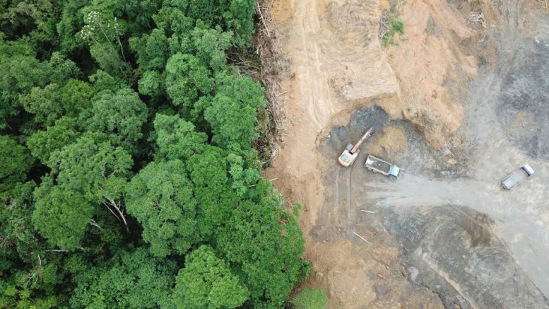
“The drought scenario in the State of Roraima increased the forest’s vulnerability to the spread of forest fires and it explains this significant increase in degradation…”
Larissa Amorim is a researcher at the Amazon Monitoring Program at Imazon – Amazon Institute of People and the Environment, with a degree in forestry engineering, and a M.Sc. in forestry sciences from the Federal Rural University of the Amazon.

Larissa Amorim, researcher at Imazon
AgriBrasilis – Forest degradation in the Amazon increased by almost 5,000% in March compared to the same month in 2023. Why?
Larissa Amorim – The degradation detected in March of 2024 in the Legal Amazon [the largest socio-geographic division in Brazil, containing all nine states in the Amazon basin] was concentrated in the State of Roraima, which is currently facing a serious drought. For the State’s main river, the Rio Branco, for example, this is the second biggest drought since 1972, when the National Water and Sanitation Agency (ANA) began monitoring it.
The drought scenario in the State of Roraima increased the forest’s vulnerability to the spread of forest fires and explains the significant increase in degradation, as this type of environmental damage is caused by both fire and logging. In other words: when we have large fires, degradation increases.
Furthermore, with the dry weather and fewer clouds in the sky, as occurred in March in the State of Roraima, satellites detect what is happening in the forest with greater accuracy. In addition to the degradation data from Imazon, fire monitoring information from the National Institute for Space Research (Inpe) showed that the State concentrated 40% of Brazil’s fire outbreaks in the 1Q of 2024.
“In March, the State recorded 31 km² of deforestation, 11% more than in March of 2023, when the deforestation reached 28 km²”
AgriBrasilis – What is the difference between degradation and deforestation?
Larissa Amorim – Deforestation occurs when the forest cover of a given area is completely removed, which is what we call “clearcutting”. Degradation occurs when part of the forest is affected, which happens mainly due to logging and fire.
In the case of logging, only species of greatest commercial value are harmed. When fires occur, the forest is also partially affected, with the death of various species.
AgriBrasilis – How is the drought situation in the State of Roraima and how is this data evaluated?
Larissa Amorim – The State of Roraima went through a severe drought in the months of February and March. The Rio Branco river, the State’s main river, reached its second lowest historical level on March of 2023, with minus 39 centimeters, according to data from the National Water and Sanitation Agency (ANA). As a result, the State government declared an emergency situation in 14 of the 15 municipalities in the State.
At Imazon, we evaluate the impact of drought on the dynamics of deforestation and forest degradation through the Deforestation Alert System (SAD). After several analyzes of satellite images carried out by the team of monitoring scientists, we issue monthly bulletins with data on the Legal Amazon. SAD data related to the month of February warned of an increase in deforestation in the State of Roraima, which went from 19 km² in 2023 to 26 km² in 2024. Furthermore, in February of 2024, 50% of forest degradation in the entire Legal Amazon was concentrated in the State. In March, the State recorded 31 km² of deforestation, 11% more than in March of 2023, when the deforestation reached 28 km². In addition to deforestation, the State had a degraded area of 2,121 km², 700 times larger than in March of last year, when the degraded area reached 3 km².
AgriBrasilis – Is remote sensing reliable for assessing the condition of forests?
Larissa Amorim – Remote sensing is a technology that allows information about the Earth’s surface to be obtained through satellite images. It is reliable and is used for different types of monitoring and studies. For our monthly monitoring of deforestation and forest degradation, we use images from NASA’s Landsat 8 and 9 satellites and Sentinel 1A, 1B, 2A and 2B from the European Space Agency (ESA). All data is in the public domain and can be accessed and used by any person or institution.
AgriBrasilis – What has been the evolution of deforestation by clearcutting in the region?
Larissa Amorim – In general, deforested areas are associated with conversion to livestock farming, agriculture or mining. Analyzing the historical series of annual accumulated data from SAD, deforestation in the Amazon has shown a gradual increase since 2018 and a significant drop in 2023. When we compare the data from 2022 compared to 2023, the reduction was 62%. This decrease was also reflected in the deforestation detected in indigenous lands and conservation units.
When we compare what was detected in 2022 in relation to 2023, the drop in deforestation in these two categories of protected areas (indigenous lands and conservation units) was 73%. These are very encouraging data, as we are talking about territories established by law to maintain natural resources and the way of life of original and traditional peoples. For deforestation to continue on a downward trend, mitigation and control actions must continue throughout the Amazon, focusing mainly on areas that suffer the greatest environmental pressure.
AgriBrasilis – Why is deforestation in the Amazon the biggest responsible for carbon emissions in Brazil?
Larissa Amorim – The Amazon occupies a large part of the Brazilian territory and, in recent years, deforestation rates have been quite high in the region. Both the removal of trees (felling) and burning are factors associated with the process of emission of carbon dioxide (CO2) which is one of the greenhouse gases. Therefore, the greater the increase in the devastation of the Amazon, the greater the emission of CO2 gases. This, in turn, intensifies the greenhouse effect process, which contributes to global warming and the occurrence of extreme weather events such as intense rainfall and severe droughts.
AgriBrasilis – Who are the villains behind deforestation in the region?
Larissa Amorim – Land grabbing is as a major problem in relation to deforestation in the Amazon. This is because public forests that do not yet have a defined use have been the main targets of illegal deforesters. In most cases, the invasion of these lands begins with logging, to remove trees of greatest commercial value from the areas. Afterwards, it is common to completely remove the remaining vegetation cover, which is the deforestation. And, with the deforested area, land use is generally converted to livestock farming, agriculture, mining and land speculation.
AgriBrasilis – What are the Imazon’s projects in the Amazon?
Larissa Amorim – Imazon currently has five research programs. They are: Amazon Monitoring, which monitors and analyzes the main human activities on the region based on satellite images and information banks; Landscape Restoration, which works to recover deforested and degraded areas in the Legal Amazon with a focus on socio-environmental inclusion; Law and Sustainability, which aims to contribute to ensuring that environmental, climate and land laws and practices in the region are compatible with zero deforestation and a development model that respects the rights of the population that keeps the forest standing; Politics and Socioeconomics, which aims to evaluate the effectiveness of public policies and private sector initiatives within the scope of the low-carbon development agenda supported by nature-based solutions and social inclusion; and Protected Areas, which supports Municipal, State and Federal governments in the creation, protection, implementation and consolidation of protected areas in the Amazon.
READ MORE: